


In Stock
ASA Metal E6B Flight Computer
 Free Shipping Available for *Orders Over $299


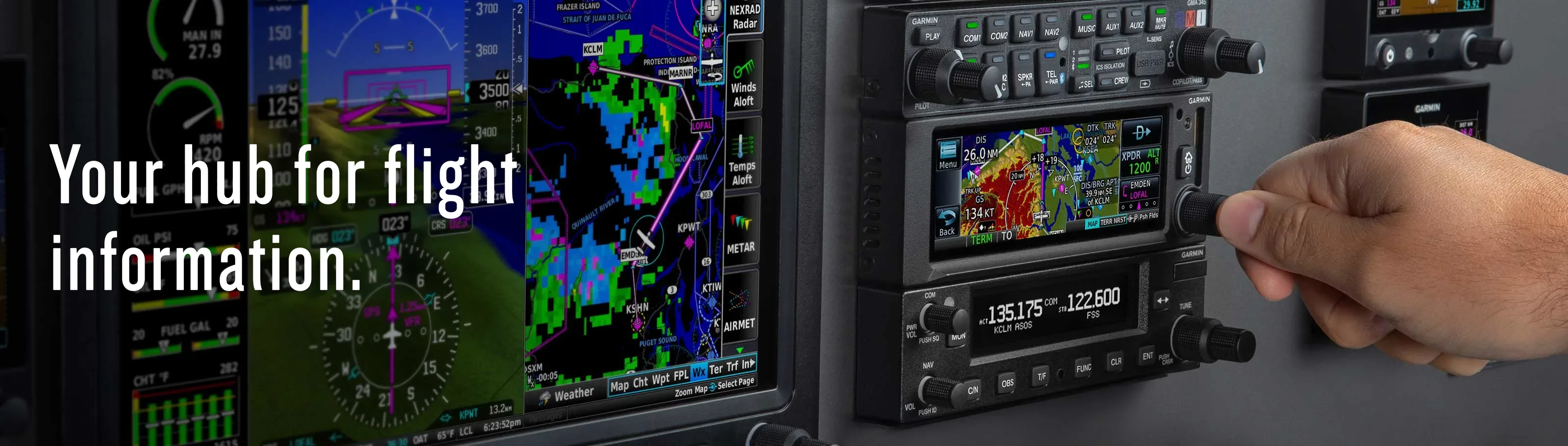
Garmin GNX 375 GPS Navigator/ADSB In/OutTransponder w/ GA35 GPS Antenna Kit STC for Certified Aircraft
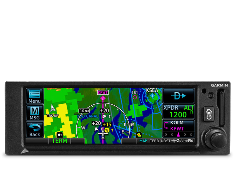
| WAAS GPS navigation enables LPV approaches with minimums as low as 200'. | Built-in 1090 MHz ES transponder meets ADS-B “Out” requirements. | Dual-link ADS-B “In” receiver provides display of traffic and weather1. | Get extensive compatibility with Garmin flight displays or existing course deviation indicators (CDIs). | Visualize your entire flight plan, including holds and approaches, on the 4.8” touch display. | Use built-in Connext® wireless technology to connect to the Garmin Pilot™ or ForeFlight |
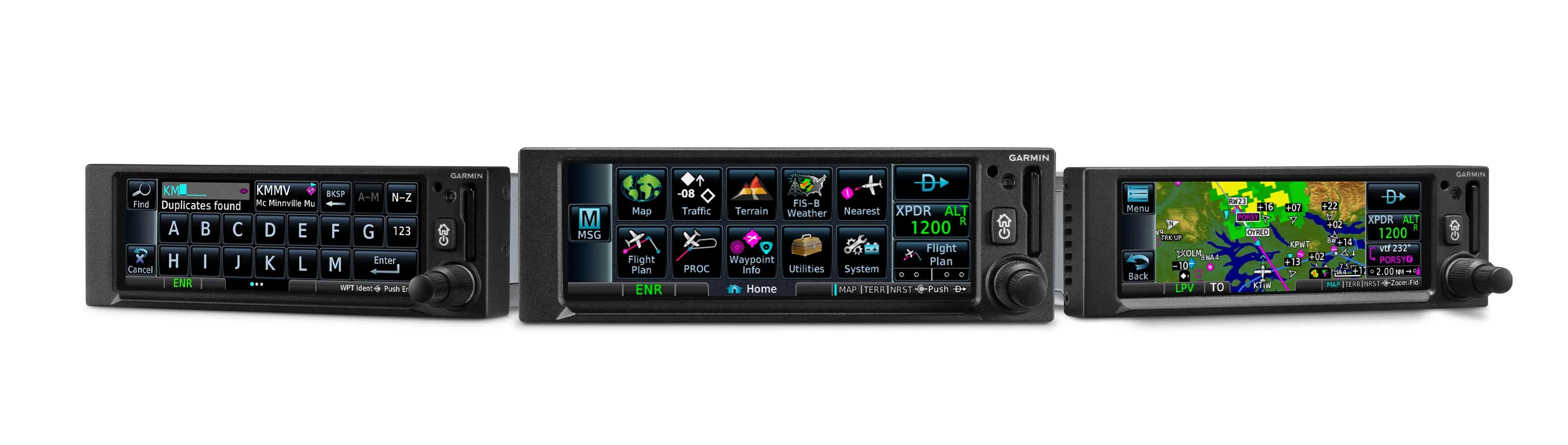
| SLIM GPS NAVIGATION | DO-IT-ALL TOUCH SCREEN | SIMPLE INSTALLATION |
| Created for Part 23 Class I/II aircraft (weighing less than 6,000 lbs) and experimental/amateur-built aircraft, GNX 375 provides a smart, affordable way to add next-generation navigation to your favorite airplane. | The intuitive touchscreen interface provides quick access to navigation, multifunction display features and more. | The GNX 375 navigator has the same 2-inch height as older navigation equipment and can allow you to keep the composite legacy CDIs already in your aircraft to minimize. |

 |
 |
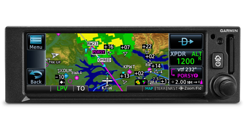 |
MULTI FUNCTION DISPLAY |
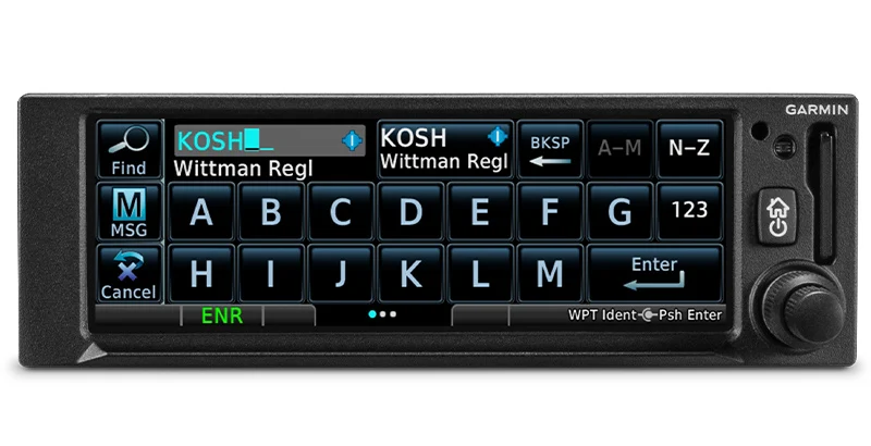
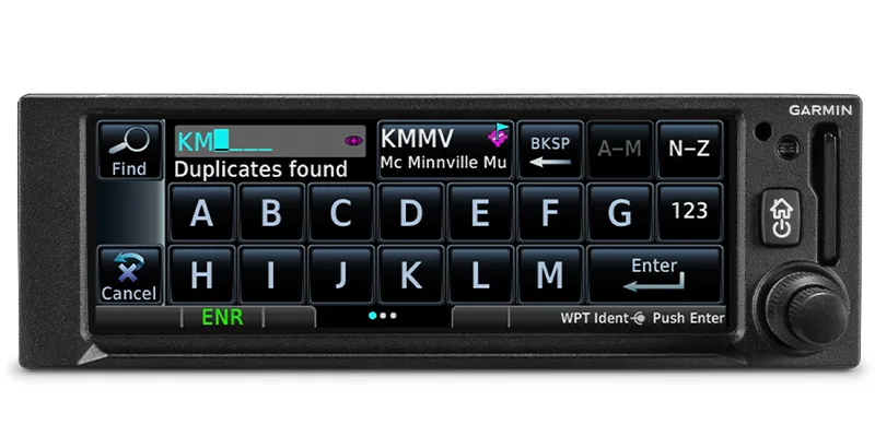
EASY DATA ENTRY |
PINCH, SWIPE GESTURES |
| The 4.8-inch display puts moving maps, terrain, traffic and weather, airport diagrams and more at your fingertips. | Use the on-screen keyboard or traditional concentric knobs to enter waypoint identifiers, routings and more. | A quick finger swipe lets you pan across the map display. Or use a smartphone-like pinch-to-zoom motion to scale up or down on any map, traffic1 or terrain page. |
 |
 |
 |
FASTFIND FEATURE |
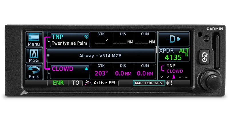
AIRWAYS, YOUR WAY |
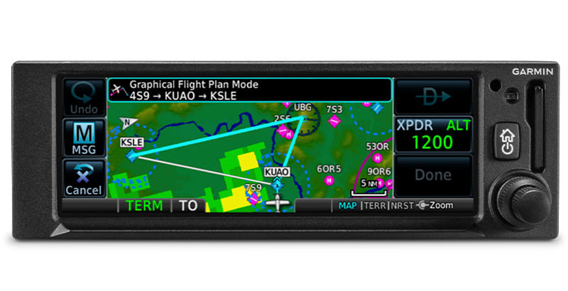
"RUBBER BAND' REROUTES |
| As soon as you start typing, the GNX 375 navigator’s FastFind feature uses quick predictive logic to suggest airport and waypoint entries by using current GPS position. Just select and go. | Victor airways can be overlaid on the map. For easy IFR routings, view airway segments available from a waypoint and corresponding exit options. | This handy feature lets you grab a flight plan leg on the screen and then stretch or move it to adjust for a deviation or ATC amendment to your flight plan. |
 |
 |
 |
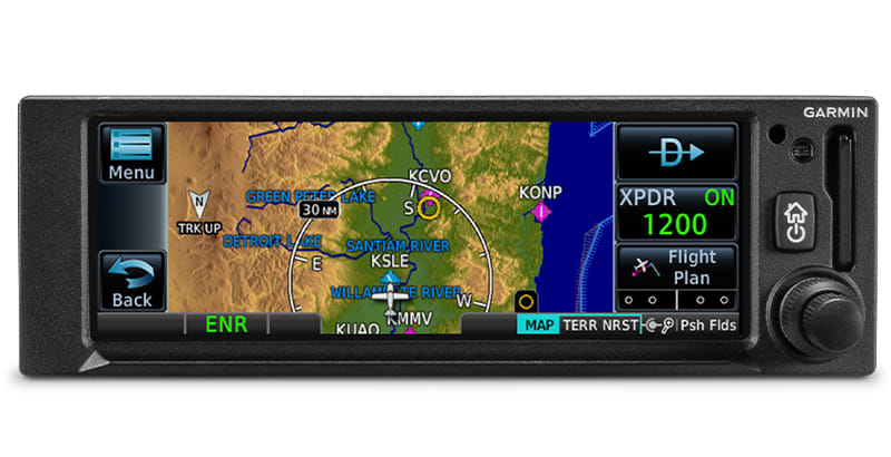
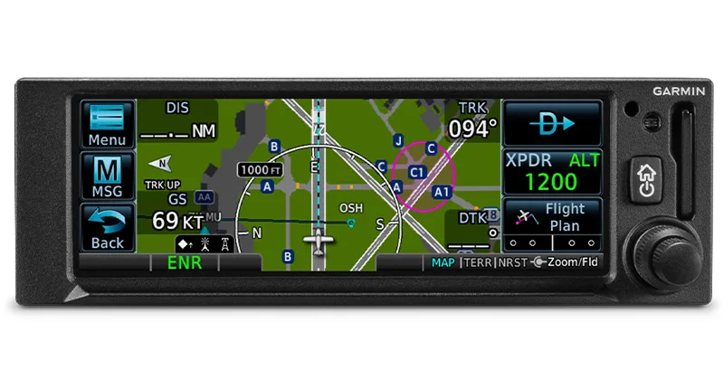
VIRTUAL MAP TOPO |
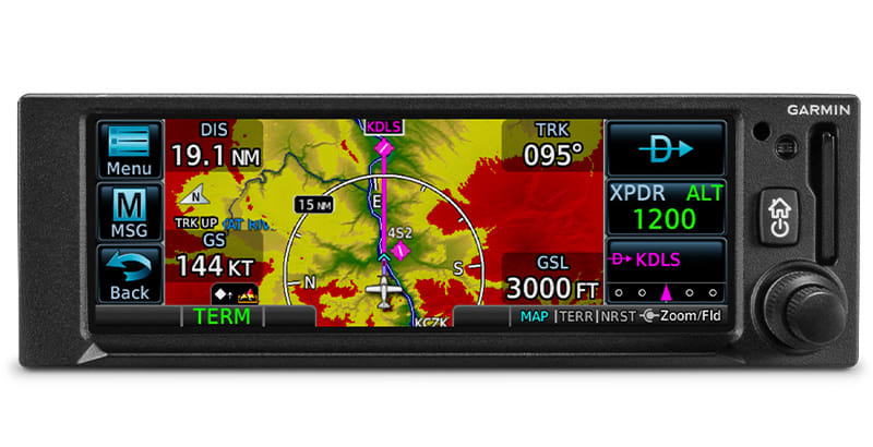
TERRAIN ALERTING |
DIRECT CONNECT |
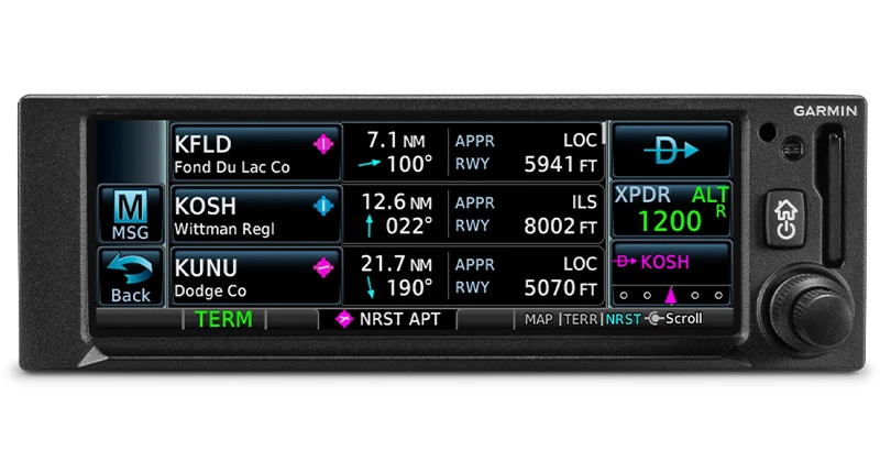
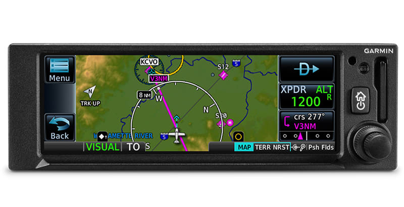
| By referencing built-in terrain, mapping and obstacles databases, GNX 375 shows detailed surface features, cities, airports, SUAs and more on the dynamic map display. | A built-in database provides color-coded display overlays to warn when potential terrain conflicts loom ahead. | A Direct-to key on almost every page lets you quickly enter a direct course for any selected waypoint. A menu of nearest airports and flight plan waypoints makes for easy entry. |

 |
 |
 |
| MORE APPROACH OPTIONS | CLEARED FOR THE VISUAL | AUTOPILOT INTERFACE |
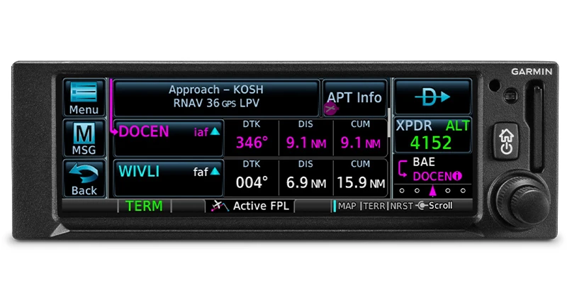
| The WAAS/SBAS-certified GPS receiver enables GPS-guided LPV glidepath approaches down to ILS-comparable minimums as low as 200’. | GNX 375 can give advisory visual approach guidance based on a published glidepath or a 3-degree slope from the runway threshold. | Precise course deviation and roll steering outputs can be coupled to Garmin autopilots, enabling virtually all IFR flight procedures to be flown automatically. |
 |
 |
|
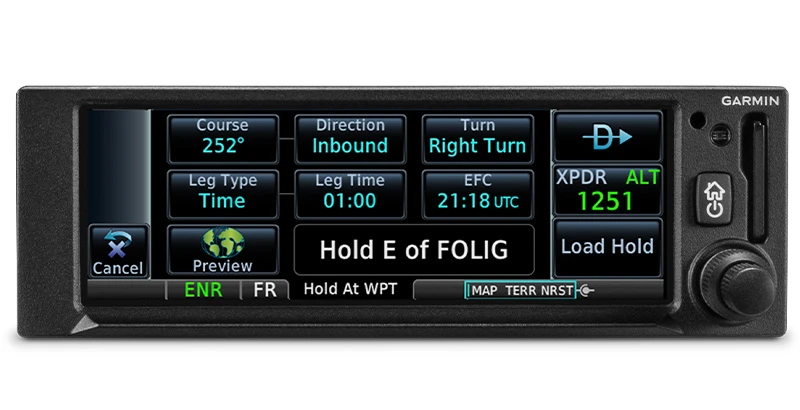
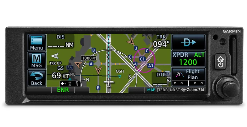
| HOLDING PATTERNS | SAFETAXI DATABASE | |
| IFR pattern entries can be tricky. The GNX 375 lets you easily create and execute holding patterns over a published or user-defined waypoint. | Upon landing, georeferenced SafeTaxi diagrams on the display automatically help you track your location on hundreds of airports. |
 |
 |
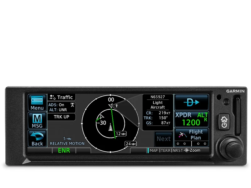 |
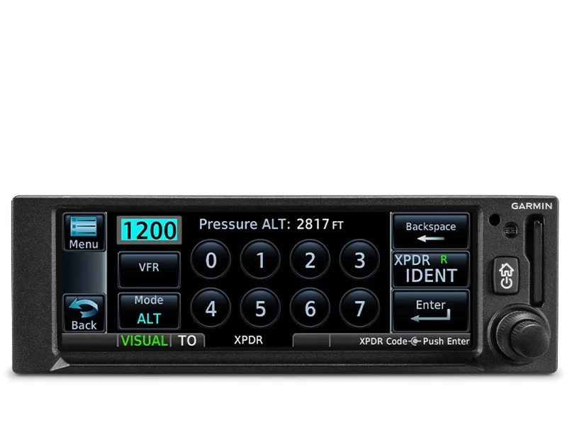
| ADS-B TRANSPONDER | ADS-B DATA LINKS | TARGETTREND TRACKING |
| With its built-in 1090 ES transponder, the GNX 375 navigator allows you to meet ADS-B “Out” requirements with a single installation. | A dual-link ADS-B “In” receiver provides a complete picture of ADS-B traffic targets as well as subscription-free weather in the U.S. | TargetTrend tracking gives pilots a faster, more intuitive way of judging traffic closure rates and trajectories. |
 |
 |
|
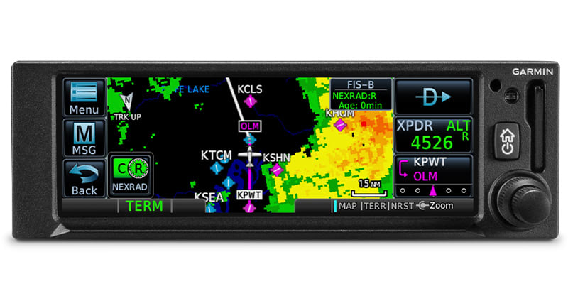
| TERMINALTRAFFIC DISPLAY | ADS-B WEATHER | |
| Providing a dynamic display of ADS-B-equipped aircraft and ground vehicles, this technology helps pilots avoid traffic conflicts within the airport environment. | Access subscription-free in-flight weather in the U.S., including animated NEXRAD imagery, METARs, TAFs, winds and temperatures aloft, PIREPs, NOTAMs and more. |
.jpg) |
 |
 |
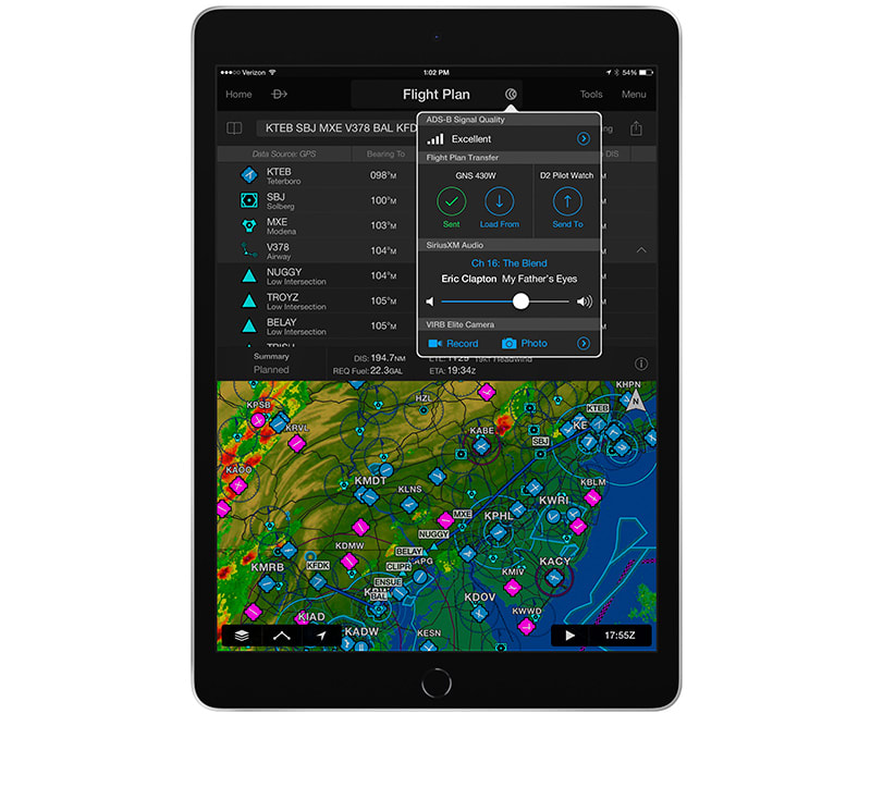
| PANEL INTEGRATION | CONNECT YOUR COCKPIT | FLIGHT PLAN TRANSFER |
| GNX 375 interfaces with Garmin flight displays, including G3X Touch™ (experimental and certified), G5 (experimental and certified), G500/G600, G500 TXi/G600 TXi and select third-party displays3 to provide navigation outputs and ADS-B weather and traffic information. | Use built-in Garmin Pilot or ForeFlight apps2. In addition to GPS data, you can stream ADS-B traffic, weather and backup attitude data to your device in real time. | Save time by creating your flight plan on your mobile device at home, then use built-in Connext technology to wirelessly upload the data into your GNX 375 during preflight at the airport. |
 |
 |
|
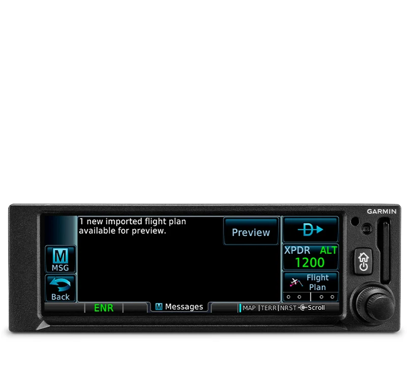
| EASY DATABASE UPDATES | TRAINER APP | |
| Install a Flight Stream 510 gateway to add Database Concierge to your GNX 375 navigator. Upload databases from your tablet in minutes — then let automatic sync with your compatible avionics do the rest. | A free iPad® Trainer app is available on the App Store®. Get familiar with the product, even before you buy! |
GNX 375
| SKU | 010-01823-51 |
| Brand | Garmin |
| Shipping Weight | 2.3000kg |
| Unit Of Measure | ea |
Help other Flight Store Pty Ltd users shop smarter by writing reviews for products you have purchased.
Write a product review
Garmin GNX 375 GPS Navigator/ADSB In/OutTransponder w/ GA35 GPS Antenna Kit STC for Certified Aircraft
| WAAS GPS navigation enables LPV approaches with minimums as low as 200'. | Built-in 1090 MHz ES transponder meets ADS-B “Out” requirements. | Dual-link ADS-B “In” receiver provides display of traffic and weather1. | Get extensive compatibility with Garmin flight displays or existing course deviation indicators (CDIs). | Visualize your entire flight plan, including holds and approaches, on the 4.8” touch display. | Use built-in Connext® wireless technology to connect to the Garmin Pilot™ or ForeFlight |
| SLIM GPS NAVIGATION | DO-IT-ALL TOUCH SCREEN | SIMPLE INSTALLATION |
| Created for Part 23 Class I/II aircraft (weighing less than 6,000 lbs) and experimental/amateur-built aircraft, GNX 375 provides a smart, affordable way to add next-generation navigation to your favorite airplane. | The intuitive touchscreen interface provides quick access to navigation, multifunction display features and more. | The GNX 375 navigator has the same 2-inch height as older navigation equipment and can allow you to keep the composite legacy CDIs already in your aircraft to minimize. |
|
|
|
MULTI FUNCTION DISPLAY |
EASY DATA ENTRY |
PINCH, SWIPE GESTURES |
| The 4.8-inch display puts moving maps, terrain, traffic and weather, airport diagrams and more at your fingertips. | Use the on-screen keyboard or traditional concentric knobs to enter waypoint identifiers, routings and more. | A quick finger swipe lets you pan across the map display. Or use a smartphone-like pinch-to-zoom motion to scale up or down on any map, traffic1 or terrain page. |
|
|
|
FASTFIND FEATURE |
AIRWAYS, YOUR WAY |
"RUBBER BAND' REROUTES |
| As soon as you start typing, the GNX 375 navigator’s FastFind feature uses quick predictive logic to suggest airport and waypoint entries by using current GPS position. Just select and go. | Victor airways can be overlaid on the map. For easy IFR routings, view airway segments available from a waypoint and corresponding exit options. | This handy feature lets you grab a flight plan leg on the screen and then stretch or move it to adjust for a deviation or ATC amendment to your flight plan. |
|
|
|
VIRTUAL MAP TOPO |
TERRAIN ALERTING |
DIRECT CONNECT |
| By referencing built-in terrain, mapping and obstacles databases, GNX 375 shows detailed surface features, cities, airports, SUAs and more on the dynamic map display. | A built-in database provides color-coded display overlays to warn when potential terrain conflicts loom ahead. | A Direct-to key on almost every page lets you quickly enter a direct course for any selected waypoint. A menu of nearest airports and flight plan waypoints makes for easy entry. |
|
|
|
| MORE APPROACH OPTIONS | CLEARED FOR THE VISUAL | AUTOPILOT INTERFACE |
| The WAAS/SBAS-certified GPS receiver enables GPS-guided LPV glidepath approaches down to ILS-comparable minimums as low as 200’. | GNX 375 can give advisory visual approach guidance based on a published glidepath or a 3-degree slope from the runway threshold. | Precise course deviation and roll steering outputs can be coupled to Garmin autopilots, enabling virtually all IFR flight procedures to be flown automatically. |
|
|
|
| HOLDING PATTERNS | SAFETAXI DATABASE | |
| IFR pattern entries can be tricky. The GNX 375 lets you easily create and execute holding patterns over a published or user-defined waypoint. | Upon landing, georeferenced SafeTaxi diagrams on the display automatically help you track your location on hundreds of airports. |
|
|
|
| ADS-B TRANSPONDER | ADS-B DATA LINKS | TARGETTREND TRACKING |
| With its built-in 1090 ES transponder, the GNX 375 navigator allows you to meet ADS-B “Out” requirements with a single installation. | A dual-link ADS-B “In” receiver provides a complete picture of ADS-B traffic targets as well as subscription-free weather in the U.S. | TargetTrend tracking gives pilots a faster, more intuitive way of judging traffic closure rates and trajectories. |
|
|
|
| TERMINALTRAFFIC DISPLAY | ADS-B WEATHER | |
| Providing a dynamic display of ADS-B-equipped aircraft and ground vehicles, this technology helps pilots avoid traffic conflicts within the airport environment. | Access subscription-free in-flight weather in the U.S., including animated NEXRAD imagery, METARs, TAFs, winds and temperatures aloft, PIREPs, NOTAMs and more. |
|
|
|
| PANEL INTEGRATION | CONNECT YOUR COCKPIT | FLIGHT PLAN TRANSFER |
| GNX 375 interfaces with Garmin flight displays, including G3X Touch™ (experimental and certified), G5 (experimental and certified), G500/G600, G500 TXi/G600 TXi and select third-party displays3 to provide navigation outputs and ADS-B weather and traffic information. | Use built-in Garmin Pilot or ForeFlight apps2. In addition to GPS data, you can stream ADS-B traffic, weather and backup attitude data to your device in real time. | Save time by creating your flight plan on your mobile device at home, then use built-in Connext technology to wirelessly upload the data into your GNX 375 during preflight at the airport. |
|
|
|
| EASY DATABASE UPDATES | TRAINER APP | |
| Install a Flight Stream 510 gateway to add Database Concierge to your GNX 375 navigator. Upload databases from your tablet in minutes — then let automatic sync with your compatible avionics do the rest. | A free iPad® Trainer app is available on the App Store®. Get familiar with the product, even before you buy! |
GNX 375
| SKU | 010-01823-51 |
| Brand | Garmin |
| Shipping Weight | 2.3000kg |
| Unit Of Measure | ea |
Help other Flight Store Pty Ltd users shop smarter by writing reviews for products you have purchased.
Write a product review


